 A new detailed map, developed by the Rivers and Fisheries Trusts of Scotland (RAFTS), identifies the most sensitive locations
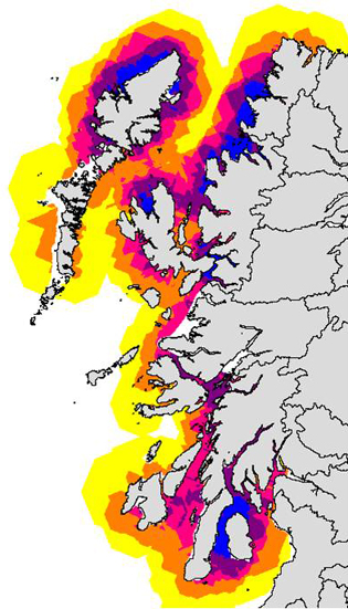
The Rivers and Fisheries Trusts of Scotland (RAFTS) has now published a detailed map of the west Highlands and Islands which suggests that more than half (57%) of the salmon farms in the area are located in the most important areas for wild salmon and sea trout.
As part of the Managing Interactions Aquaculture Project (MIAP), RAFTS has developed the map, based on a wide range of relevant criteria and risk assessments. The aim is the identification of those areas that are particularly sensitive to wild salmon and sea trout and which the aquaculture industry should avoid if damage to wild stocks is to be avoided or, at the very, least minimised.
Roger Brook, of RAFTS, said: “It is imperative that the salmon farming industry avoids those areas which are most damaging to wild salmon and sea trout. This Locational Guidance map is an evidence-based tool that pinpoints those areas.
RAFTS and other wild fisheries groups have argued for years that many fish farms are too close to migratory fish rivers, increasing the risk that sea lice released from fish farms will infect wild salmon and sea trout. It should be of major concern to all those charged with managing and regulating salmon farms that the majority of existing farms are inappropriately sited from a wild fish perspective. Serious consideration should now be given to a selective relocation programme”.
Mr Brook continued: “The development of the map was always intended as a means of influencing the planning process locally. Essentially it is an evidence-based approach to inform representations to planning proposals for new fish farm sites. Fishery trusts, fishery boards and others can use the map to improve protection of wild fish by identifying the highest risk places. No such tool has existed previously”.